Last call for light rail
If the city doesn't act now to push for light rail, Metrolinx will fund other areas.
By Rob Faulkner
Published in the Hamilton Spectator on October 20, 2008.
Today the city's public works committee will decide if it wants staff to keep pushing for light rail transit (LRT) in talks with Metrolinx, the provincial transportation agency. Staff say that if Hamilton bows out of the bid, Metrolinx will fund rapid transit in other parts of the Greater Toronto and Hamilton area. Here's how thinking on LRT continues to evolve:
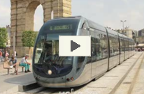
What does LRT look like?
Most systems run light, steel-wheeled vehicles on steel rails, powered by overhead electrical wires. A third rail line is a possible power source. LRT is usually at street level in mixed traffic, boarded by steps and guided by rails so drivers don't steer in traffic. Vehicles are often called trams, trolleys or streetcars.
How many lines are planned?
The city's February 2007 transportation master plan plotted three bus rapid transit lines: east-west in the lower city (B line), north-south on James (A line) and east-west, likely on the Linc.
In June 2007, MoveOntario 2020 plans cited rapid transit for Hamilton's A and B lines. But city plans have since grown to serve growth areas, hence the BLAST system.
The city concept now involves a B line, A line, T line (from near Centre Mall across Mohawk Road to Ancaster Meadowlands), the S line (Eastgate Square up Centennial to Rymal to the Ancaster Business Park), and a future L line (from downtown to Waterdown) creating an inter-regional link.
Metrolinx, in its draft regional transportation plan, identified the B line (a top 15 priority for the first 15 years), the A line (within the first 15 years), the T line (within 25 years) and the S line (beyond 25 years).
The city may ask Metrolinx to plan the S line ahead of the T line, due to road work planned on Centennial and Rymal in the next five years.
Why the focus on the B line?
Metrolinx shortlisted the B line, and the city has also focused on it. The HSR already runs an express B line bus route, which doesn't climb the Mountain, so it's thought to be able to deliver the best ridership in an affordable way. A line express buses start in fall 2009.
What structures will we see?
The city sees the Stuart Street CN rail yard as a possible LRT maintenance site. There is talk of a downtown transit hub; the B and A lines will intersect. LRT station locations are not determined.
What is the city doing next?
If authorized today, city staff will want to see the B line's analysis, functional design, detailed design and construction appear in Metrolinx's 2009-13 budget.
The city wants to start immediately on Phase 3 of its feasibility study before picking a route for the A line. This involves whether to build a $100-million tunnel so LRT can stay on steep James Mountain Road, or detour 3.5 km to the Claremont Access and miss hubs like St. Joseph's Hospital and the Hunter Street GO station. Phase 3 will look at technology, ridership, costs, etc.
What is the timeline?
Metrolinx releases its 2009-13 budget in November and says a benefits case analysis of Hamilton's B line could be done in 2009. The city says shovels could be in the ground in 2011.
What about environmental assessments?
Hamilton has not done environmental assessments but says some of its work so far, like public consultation, will fulfil part of the EA process. The city still has to study archaeology, alternate routes, and more.